Nation-Wide Mapping Of Tree
In collaboration with M. Mugabowindekwe & M. Brandt; see Mugabowindekwe, M., Brandt, M., Chave, J. et al. Nation-wide mapping of tree-level aboveground carbon stocks in Rwanda. Nat. Clim. Chang. 13, 91–97 (2023). https://doi.org/10.1038/s41558-022-01544-w
Abstract
Trees sustain livelihoods and mitigate climate change but a predominance of trees outside forests and limited resources make it difficult for many tropical countries to conduct automated nation-wide inventories. Here, we propose an approach to map the carbon stock of each individual overstory tree at the national scale of Rwanda using aerial imagery from 2008 and deep learning. We show that 72% of the mapped trees are located in farmlands and savannas and 17% in plantations, accounting for 48.6% of the national aboveground carbon stocks. Natural forests cover 11% of the total tree count and 51.4% of the national carbon stocks, with an overall carbon stock uncertainty of 16.9%. The mapping of all trees allows partitioning to any landscapes classification and is urgently needed for effective planning and monitoring of restoration activities as well as for optimization of carbon sequestration, biodiversity and economic benefits of trees.
Main
Trees both inside and outside forests are important features of many ecosystems1. Individual tree traits are key determinants of ecosystem services including carbon storage, climate regulation and fuel wood2,3. Many countries regularly evaluate, quantify and monitor forests using field inventories as part of national forest monitoring systems Forest inventories are the backbone to measurement, reporting and validation (MRV) for climate change mitigation initiatives such as national level REDD+ (reducing emissions from deforestation and forest degradation), Sustainable Development Goals (SDGs) especially SDG 15 (ref. ), the Paris Agreement and the Bonn Challenge. In many northern countries, sample-based forest inventories are often accompanied by airborne LiDAR campaigns, providing detailed information on the carbon stocks of forests. However, field inventories and LiDAR campaigns are expensive and labour intensive resulting in trade-offs between accuracy, reproducibility and the frequency of reporting. In many tropical countries, financial and human resource constraints limit the coverage and frequency of the field inventories.
This is particularly problematic for many African countries, where submetre and country-scale LiDAR data are not available across a variety of landscape types, ranging from savannas, woodlands, subhumid and humid forests, to highly fragmented, small-scale agro-ecosystem mosaics This complexity makes it difficult to scale from sparsely sampled plots to the national scale. Indeed, many of these landscapes are dominated by non-forest trees which are very difficult to map with traditional methods
Inventories and existing large-scale tree cover maps often omit an accounting of trees growing outside forests, which is related to differences in forest definitions, mapping techniques and the complexity of the environment. This leads to incomplete censuses of trees and their related benefits and services at a national scale. More specifically, these inaccuracies aggravate the existing uncertainties in estimates of both national carbon stocks and emission reference levels and may confound the relative contributions of emissions attributed to forest degradation or deforestation. In turn, these inaccuracies in tree mapping complicate adequate natural resource management, climate change decision-making and policy formulation These challenges are especially notable in the tropics, where many landscape restoration projects have been initiated without fully functional monitoring systems in place.
In Africa, the rate of tree cover loss in natural forests and projected biomass losses from climate change have prompted both policy and economic initiatives for the restoration of tree-dominated landscapes. Ongoing initiatives include the African Forest Landscape Restoration Initiative (AFR100), with more than 30 African governments making commitments to restore at least 100 million hectares of land across the continent by 2030 the Africa Low Emissions Development Strategiesand the Great Green Wall initiative However, there is currently no accurate and regularly updated monitoring platform to track the progress and biophysical impact of these initiatives. Here, we propose an approach for rapidly and accurately mapping individual trees and quantifying their carbon stocks at national scale. We also illustrate how the aforementioned challenges can be addressed with efficient new monitoring tools, using Rwanda as a demonstration. The country is a signatory to most of the above-mentioned global climate mitigation initiatives and regularly reports on their implementation. Rwanda targeted at least 30% of the country to be covered by forests by the year 2020 , which was achieved in 2019 and, under the Bonn Challenge, the country has also committed to restore 81% of the country’s surface area by 2030 (refs, Moreover, Rwanda represents a great example of a place with contrasting landscape types, the full range and variety of tree-based systems and a rich mixture of land uses: drylands dominated by savannas and pastureland, plateaus dominated by agriculture and humid highlands dominated by natural forests and protected areas, including tropical montane rainforest
Recently, it was demonstrated that advanced machine learning techniques can map individual trees over large dryland areas However, the analysis was limited to isolated trees in savannas excluding small trees with a crown area <3 m2 and did not cover other complex and heterogeneous ecosystems such as woodlands and forests. Here, we use aerial images and map both crown size and carbon stock of each individual overstory tree in Rwanda, regardless of ecosystem type. We define trees as woody plants visible from above and with a crown size of at least 0.25 m2 and a visible shadow. We also show the applicability of the model trained in Rwanda in other African countries using satellite imagery. This study suggests a rapid, reproducible and highly accurate way to upscale field inventory data collected at the level of individual trees to the entire country. This will allow tree inventory reports to be of unprecedented accuracy and can support MRV of climate change mitigation initiatives.
Mapping Individual Trees At National Scale
Aerial images with a spatial resolution of 25 × 25 cm2 were acquired in 2008 covering the entire country A deep-learning model was trained using 97,574 hand-labelled tree crowns and then used to map 355,268,345 trees with crown size >0.25 m2 (excluding understory). The crown area threshold was set on the basis of visual inspection of the images, as trees of this size are still clearly visible Clumped crowns were separated using a postprocessing method that determines the crown centres in the predictions, assuming that tree crowns have round shapes. The method then relabels the crown predictions on the basis of weighted distances to the identified crown centre Crown area and count predictions were validated with an independent test dataset and field data.
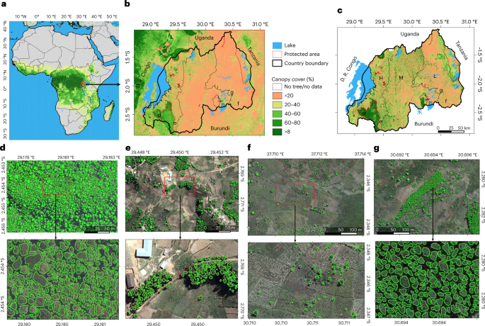
a,b, Tree cover from a previously published global tree cover map using Landsat data in Africa (a) and in Rwanda (b). Global tree cover data in a and b from ref. c, Country-wide tree cover estimated by deep learning from 0.25 m resolution aerial imagery from 2008 (L, lowlands; M, midlands; H, highlands). Labels d–g in a and b show location of expanded panels. d–g, Examples of individual tree crown mapping in tropical montane rainforest, note that artificial gaps were filled during a postprocessing step (d); Eucalyptus plantations (e); farmlands (f); and Pinus plantations (g). An example of previously published manual forest area delineations is shown in Extended Data Boundary shapefiles of Rwanda in b and c from Panel e adapted with permission from ref. Springer Nature Limited. Credit: photographs in d–g, Swedesurvey.
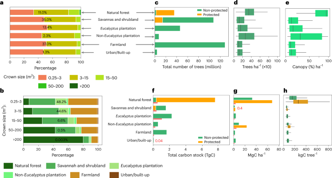
Following a manual delineation, which is based on the same aerial images as used here and which includes forest patches down to a size of 0.25 ha , we stratified the landscapes into broad classes that can be found in most African countries: natural forest (including both large rainforest trees in the Nyungwe park in the southwest of Rwanda and smaller trees in the volcanoes park in the northwest), Eucalyptus plantations (excluding isolated Eucalyptus trees in farmlands), non-Eucalyptus tree plantations, farmlands, urban and built-up areas, as well as savannas and shrublands We further subdivided each class in protected and non-protected areas. Overall, our results show a dominance of trees with small crown sizes of 0.25–3 m2, which account for 48.2% of the mapped trees, followed by trees with crown sizes of 3–15 m2, which account for 44.6% of the trees. Related to our land stratification, these two crown size ranges are dominant in farmlands and Eucalyptus plantationsTrees of the largest crown size class (crown sizes >200 m2) are very scarce and mainly found in natural forests which dominate areas under protection.
a, Percentage covered by different crown sizes in each land cover/use type. The percentage number shows the contribution of the land cover/use type to the total area. Crown sizes >200 m2 comprise only 0.003% of the total tree count, making the class barely visible. b, Percentage covered by each land cover/use type in different crown size categories. c, Total count of trees by land cover/use. d, Boxplot showing the average number of trees per hectare by land cover/use type. e, Same as d but for canopy cover. f, Total estimated carbon stock per land cover/use type for details on uncertainties and error propagation). g, Barplot showing the average carbon density per hectare per land cover/use. h, Boxplots showing the average carbon stock per tree per land cover/use. Number of trees = 355,268,345 (for c–h, n = 39,347,302 for natural forest; 123,381,245 for savannah and shrubland; 47,921,438 for Eucalyptus plantation; 8,296,494 for non-Eucalyptus plantation; 131,822,508 for farmland; and 4,499,358 for urban/built-up). In boxplots in d, e and h (from left to right), the start of the horizontal line represents the minimum value, vertical lines represent first quartile, median and third quartile values, respectively, and the end of the horizontal line represents the maximum value. The red lines in f and g are the error bars presented as absolute difference between the final carbon stock predictions and the NFI data (Extended Data Table . The overall uncertainty at national scale is 16.9%
We show that only 11% of the mapped trees are located inside natural forests, whereas most trees are located in farmland (37%). Specifically, natural forests have 39.3 million trees, with a median density of 298 (s.d. 159) trees ha−1 and a median canopy cover of 96.0% (s.d. 31.7). Farmlands have a median tree density of 64 (s.d. 139) trees ha−1 and a median canopy cover of 7.6% (s.d. 18.7). Eucalyptus plantations account for about 48 million trees (~13.4% of the total mapped trees), a median density of 110 (s.d. 195) trees ha−1 and median canopy cover of 13.9% (s.d. 26.3). Here the canopy cover is low because the manually drawn classification of plantation areas also includes bare areas close to plantations (Extended Data Fig. 1). Non-Eucalyptus tree plantations have 8.3 million trees (~2.3% of the total mapped trees), a median density of 221 (s.d. 222) trees ha−1 and a median canopy cover of 31.5% (s.d. 37.8). Urban and built-up areas have 4.5 million trees (~1.3% of the total mapped trees) and a median density of 74 (s.d. 142) trees ha−1. Savannas and shrublands account for 123.3 million trees (~35% of the total mapped trees), with a median density of 100 (s.d. 164) trees ha−1 and a median canopy cover of 12.2% (s.d. 23.2). Overall, trees outside of natural forests are about 315.9 million trees of which 41.6% are in farmlands. The quantification of non-forest trees depends on how forests are defined. A total of 89% of the trees in Rwanda do not belong to the classes of natural forests and can thus be considered as trees outside natural forests.
The importance of protected areas for tree density and count is worthwhile to note. Although they cover only 5% of the country, they have 11% of the total mapped trees with the highest median tree density of 298 trees ha−1 as well as the highest median canopy cover of 96.3%. Overall, 20.8% of Rwanda was covered by trees (canopy cover) in 2008.
Carbon Stocks Estimated For Individual Trees
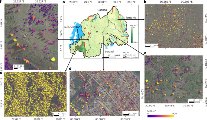
We used data from a field campaign in December 2021 and existing databases to estimate the stem diameter from the mapped crown sizes via allometric equations We then estimated the aboveground carbon stocks for each tree using existing equations based on stem diameter Extended Data FigsWe established land cover class-specific relationships and report here the combined results using allometric equations from ref. for natural forest; ref. for Eucalyptus and non-Eucalyptus plantations, farmlands and urban and built-up areas; and ref. for savannas and shrublands. For each class, we evaluated the aggregated carbon stocks with data from the Rwanda National Forest Inventory (NFI) from 2013/2014 and field data from refs. covering all land cover classes and serving as a measure of uncertainty which we quantify to 16.9% at national scale. We estimate a total of 14.3 ± 2.8 Tg (± is the uncertainty) of aboveground carbon stocks in trees For areas outside the natural forests, we estimate 7.0 ± 1.1 TgC, which is 48.6% of the total national aboveground carbon stocks and slightly lower than NFI estimates (8.4 TgC). Farmlands have a total estimate of 3.5 ± 0.2 TgC corresponding to 24.4% of the national aboveground C stock with a C density of 3.0 ± 0.18 (s.d. 3.2) MgC ha−1. Urban and built-up areas have 0.1 ± 0.006 TgC corresponding to 1.03% of the national aboveground C stock with a C density of 4.0 ± 0.24 (s.d. 4.0) MgC ha−1. Eucalyptus plantations comprise a total estimate of 1.1 ± 0.6 TgC corresponding to 7.7% of the national aboveground C stocks, with a C density of 4.2 ± 2.2 (s.d. 4.3) MgC ha−1. These low estimates can be explained by sparse tree planting and the regular harvesting keeping the trees young Non-Eucalyptus plantations have a total estimate of 0.3 ± 0.16 TgC corresponding to 2.2% of the national aboveground carbon stocks, with a C density of 10.0 ± 5.2 (s.d. 9.9) MgC ha−1. Savannas and shrublands have 1.9 ± 0.36 TgC corresponding to 13.2% of the national aboveground C stock with a C density of 2.4 ± 0.45 (s.d. 2.4) MgC ha−1. For natural forests, we estimate a median C density of 81 ± 21 MgC ha−1 for areas where field data are available (the Nyungwe tropical montane rainforest), which is lower than the field measurements of 121 MgC ha−1 possibly due to trees from lower layers not visible from above. Overall, we estimate that 51.6% of the total national aboveground carbon stocks are in natural forests with a total estimate of 7.4 ± 2.47 TgC and an overall C density of 62 ± 20 (s.d. 31.2) MgC ha−1.
a, Spatial distribution of the estimated carbon stock across the major landscape types. b–f, Examples of estimated carbon stock per individual tree in wooded savanna (b), farmland (c), Kigali city (d), the tropical montane rainforest in the Nyungwe National Park (e) and in tree plantations (f). Boundary shapefiles of Rwanda in a from . Credit: photographs in b–f, Swedesurvey.
Scalability Of The Approach
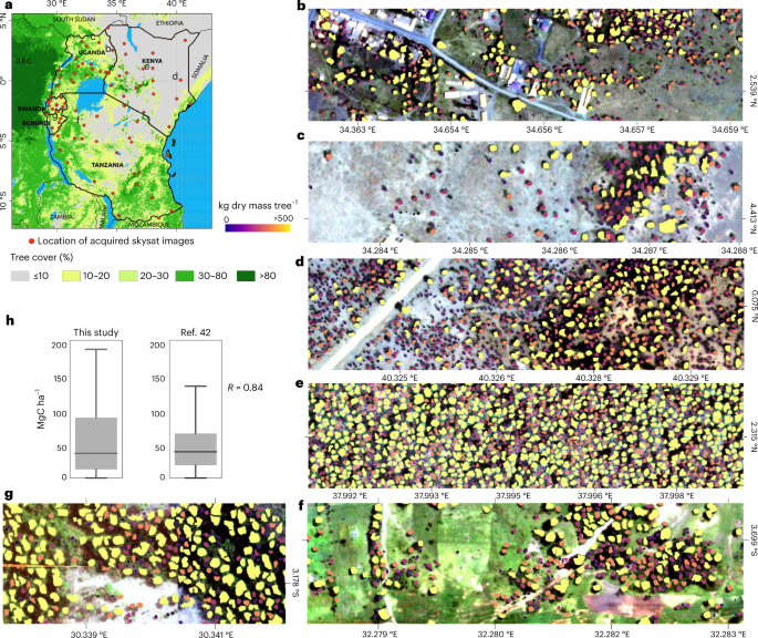
We acquired 83 Skysat images at 80 cm ground sampling resolution for 2019–2021 for Tanzania, Kenya, Uganda, Burundi and Rwanda and directly applied the model trained with the aerial images from Rwanda The tree detection and crown delineation work elsewhere, even beyond Africa We then compared the predicted carbon density from 150 randomly selected 1 × 1 km2 patches with previously published maps of biomass Both the magnitudes of the predictions and the spatial correlation (R = 0.84) match well with the most recent map
a, The location of the acquired 83 Skysat images across East Africa. Tree cover data from ref. . b–g, Examples of tree-level carbon stock predictions for Uganda (b,c), Kenya (d,e), Tanzania (f) and Burundi (g). h, A total of 150 random (n = 150) 1 × 1 km2 samples were used to aggregate the predicted tree-level carbon stocks, then compare the results to a previously published map using two-tailed Pearson correlation (P < 0.001). The boxplot lines from top to bottom represent the maximum, third quartile, median, first quartile and minimum values. See Extended Data Fig. for more comparisons. Boundary shapefiles of East African countries in a from DIVA-GIS. Credit: photographs in b–d, Skysat.
This analysis presents an assessment of all overstory trees, aside from the assessment of their cover, density or land use. We estimate aboveground carbon stocks at the tree level, not on an aggregate area basis as it has been in most previous carbon stock mapping. This approach is more closely aligned with standard methods and protocols for allometric scaling of carbon from inventory plots. Most allometric scaling from a tree parameter to biomass or carbon involves nonlinear relationships, where the size class distribution of trees matters for the final estimate of landscape carbon stocks. Furthermore, the ability to map all trees makes our assessment independent of forest, tree cover and land use definitions. Reporting carbon stocks on the basis of individual trees would solve important uncertainties caused by definitions, methods, data sources and spatial resolution. Our example shows that even a very detailed manual forest delineation approach missed 38.4% of the isolated trees in Rwanda, which account for 25.5% of the national aboveground carbon stocks. With results as presented here, management and conservation decision-making can be more targeted by discriminating various types of tree systems under specific conditions and in specific locations. Our approach therefore could support management of a broad array of tree-based systems such as agroforestry, as well as catalyse important cross-sector management strategies inclusive of Agriculture, Forestry and other Land Use (AFoLU). A focus on AFoLU provides a way to simultaneously manage both emission reductions and removals of greenhouse gases Integrating non-forest trees in conservation initiatives expands the scope of climate change mitigation and adaptation efforts by also accounting for trees not included in standard forest assessments Forests have been an important focal point for land cover change monitoring for decades and progress has been made developing tools and methods applied to forests However, less effort has been given to monitoring trees and carbon stocks for trees outside of forests. This would provide a more robust approach for reducing emissions and increasing removals, making it possible to implement comprehensive national climate change mitigation actions in countries with mostly sparse tree cover. This analysis deploys a complete inventory of trees in AFoLU as a comprehensive approach that could support a more inclusive formulation of national programmes. Moreover, when considering the large number of trees in croplands, it is possible to monitor—and thus include in policies—economically poor rural communities in marginal landscapes that are particularly vulnerable to climate change. Quantitative data as presented here have the potential to link both mitigation and adaptation in a single framework. Many of the non-forest tree systems have direct connections to livelihoods and therefore are also important for economic development, poverty alleviation and climate change resilience and adaptation. Through innovations in landscape management practices using tree-based systems and associated monitoring and reporting systems, millions of farmers could be important participants in climate change mitigation actions, while also enhancing their livelihoods at the same time. By bringing a broad array of tree-based systems into carbon monitoring platforms, there is an opportunity to increase the engagement of countries with low tree densities in climate change mitigation.
The aerial images and NFI data used here have a high quality and cover the entire country, which is a ‘best-case’ scenario that can hardly be met by countries with limited resources and heterogeneous landscapes. However, we have demonstrated that our model trained on aerial images in Rwanda can be directly applied on images from Skysat satellites, which can be obtained for a reasonable price for monitoring restoration projects.
We acknowledge that a satellite- or aerial image-based approach cannot resolve the full range of crown sizes because small trees are shaded out by large trees, and also the conversion of crown area to carbon stocks includes uncertainty). To reduce uncertainty, future versions of the proposed method should include more localized field inventory databases that allow for more local biome and species-specific wood densities and allometric conversions, as well as integrate tree height estimations from field and airborne LiDAR surveys. Ideally, national inventories are coupled with results such as those presented here to identify systematic bias and optimize the upscaling from field plot information to country scale. If limited funds are available, low-cost imagery from PlanetScope or Sentinel-2 may be trained with tree-level data such as provided here, which would also allow a deeper temporal dimension.
Having the capability of mapping tree-level carbon stocks is important to a range of applications including monitoring of forest landscape restoration, tree plantation survival rate, forest demography: dynamics of mortality and recruitment, tree-dominated land ownership, payments for ecosystem services, issuance of concession permits and tracking compliance, among other benefits. Therefore, we emphasize the inclusion of funding for regular high-resolution imagery along with localized field inventory databases in development packages. We also highlight the relevance of all trees for conservation and protection efforts and encourage that trees outside forests are considered as equally important as trees in forests.


Leave a Reply